‘THE SCIENCE’
WITH THANKS TO
Science and Technology Facilities Council & RAL Space UK/Australia AgroClimate Space Programme:
Using Earth Observation Data and Technology for Agriculture and the Climate
‘The Ecosystem of Agriculture using Earth Observation’
We have identified four pillars of this ecosystem;
The Climate, Plants & Trees, Animals (with a focus on livestock) and Water.
Below you will find regular updates to ACTIVITIES & INFORMATION to inspire your child’s artwork for the ENVIRONMENTAL category submission.
Activities and information range from levels 1 (for everyone) to 3 (more advanced)

For ‘World Water Day’ 2022, SISTERS GRIMM LAUNCH “LIFE” SINGLE AND MUSIC VIDEO FOR “AUSTRALIA ART IN NATURE
‘Life’ by Corinne Gibbons and Ella Spira MBE featuring Oswald ‘Uncle Ossie’ Cruse For ‘World Water Day’ 2022, this animated music video, features winning nature and science inspired artworks from over 700 submitted by children all over Australia, with an original song, composed by Australian singer-songwriter Corinne Gibbons and Grammy nominated Ella Spira MBE and […]
Read more »
INFORMATION LEVEL 2: DO YOU KNOW what False Colour Imagery is? Making the invisible visible!
Click this link to hear DR Hugh from RAL Space talk about what False Colour Imagery is and how building instruments that observe the universe, means we can see way beyond the capabilities of the human eye! Can you imagine being able to make the invisible visible! https://www.facebook.com/RAL.Space/videos/dr-hugh-mortimer-what-is-false-colour-imagery/268021300916825/
Read more »
INFORMATION LEVEL 3: INTRODUCING CSIRO AquaWatch safeguarding freshwater and coastal resources
Water is our most important and vital resource. The health of our inland waterways and coastal environments is essential for maintaining safe water for drinking, for use by primary industries and for preserving our natural environments. CSIRO and their collaborating partners aim to establish an integrated ground-to-space national water quality monitoring system by 2026, to safeguard […]
Read more »
INFORMATION LEVEL 2: What do Australian mangroves, seagrasses and tidal marshes have in common?
They are also known as ‘blue carbon’ ecosystems that lock up carbon at faster rates than most land ecosystems! AND DID YOU KNOW: Australia harbors about 12 per cent of the World’s blue carbon ecosystems, which hold about 7-12 per cent of global carbon stock! To find out more about benefits these ecosystems provide for for coastal […]
Read more »
ACTIVITY LEVEL 1: DRAW A BIRDS EYE VIEW OF YOUR LOCAL FARM USING GOOGLE EARTH!
Use Google Earth to inspire your nature artwork of your nearest farm. https://earth.google.com/web/ IMAGE: Satellite image of paddocks in Western Australia overlaid with boundaries as identified with our new farm mapping software. Credit: Copernicus Sentinel Data. https://blog.csiro.au/epaddock-farm-mapping-software/
Read more »
ACTIVITY LEVEL 2: Create an Artwork of your favourite food that grows from the ground?
Image: Vincent Van Gogh ‘Wheat Field With Crows’
Read more »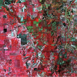
INFORMATION LEVEL 3: Satellite imagery helping farmers
https://ecos.csiro.au/remote-sensing-for-farmers/ The boundary between art and science. Crops (the red area on the left), rivers (in the centre area), bushland (black) and less vegetated areas (green on the right) in 74×54 kms of Western Australia. Credit: European Space Agency. There’s a high-tech tool increasingly available to farmers from Australia to Africa – remote sensing data […]
Read more »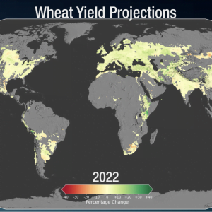
INFORMATION LEVEL 3: Crop projections using climate simulation models
https://svs.gsfc.nasa.gov/4914 https://svs.gsfc.nasa.gov/vis/a000000/a004900/a004914/WheatMapFuture.mp4 Climate change will affect agricultural production worldwide. Average global crop yields for maize, or corn, may see a decrease of 24% by late century, if current climate change trends continue. Wheat, in contrast, may see an uptick in crop yields by about 17%. The change in yields is due to the projected increases […]
Read more »
INFORMATION LEVEL 1 DID YOU KNOW: Australia’s Indigenous cultures had completely different seasons each designed around local weather conditions?
http://www.bom.gov.au/iwk/calendars/nyoongar.shtml In the southwest of Australia, the Nyoongar seasonal calendar includes six different seasons in a yearly cycle These are Birak, Bunuru, Djeran, Makuru, Djilba and Kambarang. Each of the six seasons represents and explains the seasonal changes we see annually. The flowering of many different plants, the hibernation of reptiles and the moulting of […]
Read more »
INFORMATION LEVEL 1: INTRODUCING CSIRO researcher and satellite operator: Dr Amy Parker
Australia is one of the biggest users of satellite Earth observation data. The only way to see our vast country is from space. Meet Dr Amy Parker and see how she’s helping make satellite data more accessible to Australian researchers. “I had no idea this would be my dream job! If you’d told me as […]
Read more »
INFORMATION LEVEL 1 DID YOU KNOW: CSIRO is working with Australia’s first and only Aboriginal owned-and-operated ground station provider to bring NovaSAR-1 data down to Earth?
https://blog.csiro.au/novasar-1-research-facility/ Our NovaSAR-1 satellite research facility is helping Australian researchers understand more about our Earth. Australia’s first and only Aboriginal owned-and-operated ground station provider is helping us bring that data down to Earth. The ground station, located near Alice Springs and owned by the Centre for Appropriate Technology (CfAT), will download the data from the satellite as it […]
Read more »
ACTIVITY LEVEL 2: To discover whose Country is sustaining you, look at Horton’s map!
The map attempts to represent the language, social or nation groups of Aboriginal Australia. It shows only the general locations of larger groupings of people which may include clans, dialects or individual languages in a group. It used published resources from the eighteenth century-1994 and is not intended to be exact, nor the boundaries fixed. […]
Read more »
INFORMATION LEVEL 1: INTRODUCING Earth observation scientist Dr Hugh Mortimer RAL Space | UKRI STFC Rutherford Appleton Laboratory !
Climate change pioneer*, Dr Hugh is an Earth observation scientist, which includes many different disciplines of science: biology, geology, physics engineering. Hugh’s focus is on developing new types of instruments to be used in space, to help detect different concentrations of gases in the atmosphere. To also map the global temperature distribution of the earth’s […]
Read more »
ACTIVITY LEVEL 2: EXPLORE A VIRTUAL REALITY LANDSCAPE MODEL!
TAKE A LOOK AT THIS virtual reality model of an Australian Box Gum Grassy Woodland landscape, an endangered eucalypt woodland ecosystem that is difficult to observe in its intact pre-European colonisation form. The models could potentially be used as a resource for ecological study and conservation. https://www.youtube.com/watch?v=dLHK8THukz8
Read more »
INFORMATION LEVEL 2: DID YOU KNOW? Researchers have developed immersive virtual landscapes of intact endangered Australian ecosystems to accurately illustrate changes across time, seasons and following disturbances like bushfires.
Image: Recreating the endangered woodlands included capturing the yellow Bulbine lily by modelling it in 3D in the understorey of the virtual landscape CSIRO https://www.csiro.au/en/news/News-releases/2021/Virtual-landscapes-to-study-endangered-Australian-ecosystems The study created a virtual reality model of an Australian Box Gum Grassy Woodland landscape, an endangered eucalypt woodland ecosystem that is difficult to observe in its intact pre-European colonisation […]
Read more »
INFORMATION LEVEL 1: COUNTRY
COUNTRY is an area of land that is directly related to a group of Aboriginal peoples through ancestry, cultures and languages. Country is alive and intelligent providing everything that it’s people need. Country exists outside as a living, vital place that we inhabit and through learning culture and respect it also exists inside as a […]
Read more »
INFORMATION LEVEL 2 : INTRODUCING Karlie Alinta Noon !
Karlie Alinta Noon is the first indigenous woman in Australia to graduate with a double degree in maths and physics, an astronomer, of the Gamilaraay people, multiple award winner, 2019 Eureka Prize nominee, and one of the 2017 BBC’s 100 Women. Photo:University of Newcastle http://www.aboriginalastronomy.com.au/people/karlie-noon/ “Indigenous peoples around the world have understood the stars, tides […]
Read more »
ACTIVITY LEVEL 1: Is there a pond/ lake/ river/ waterfall/ ocean near you for your child to create an artwork?
This artwork is called “Country *1 Water ways” by Allan James Phillips. His ancestry is that of the Worimii, Guringai and Gumbaynggirr peoples of NSW, Australia. With Irish/European descent to complete the whole of self. Or as he says. “I am Onemob”! https://onemobdreaming.com/index.html
Read more »
INFORMATION LEVEL 2 : Soil Moisture Maps and Australian Rainfall
INFORMATION LEVEL 2 : Soil Moisture Maps and Australian Rainfall https://svs.gsfc.nasa.gov/30599 Water is one of the most important components of soil, but the volume of water contained within a given volume of soil—or soil moisture—can fluctuate annually, seasonally, daily, and even hourly, due to changes in water availability from precipitation, irrigation, and evaporation from the […]
Read more »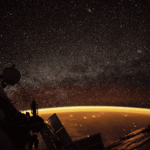
INFORMATION LEVEL 3: Airglow-australia
INFORMATION LEVEL 3: Airglow-australia: https://svs.gsfc.nasa.gov/31115 On October 7, 2018, an astronaut onboard the ISS shot this photograph at an altitude of about 250 miles (400 kilometers) over Australia. In this view, stars appear more numerous along the image center where the plane of the disk-shaped Milky Way galaxy extends into space. The orange colors enveloping […]
Read more »
ACTIVITY LEVEL 1: Explore Google Earth
ACTIVITY LEVEL 1: Explore Google Earth. DID YOU KNOW? You can find your area, even your home itself on ……. Google Earth “Earth Observation helps us to work more intelligently with our environment. Helps us to manage the scarce resources that we have and to optimise mundane things. You can avoid traffic by using intelligent satellite […]
Read more »