INFORMATION LEVEL 3

INFORMATION LEVEL 3: INTRODUCING CSIRO AquaWatch safeguarding freshwater and coastal resources
Water is our most important and vital resource. The health of our inland waterways and coastal environments is essential for maintaining safe water for drinking, for use by primary industries and for preserving our natural environments. CSIRO and their collaborating partners aim to establish an integrated ground-to-space national water quality monitoring system by 2026, to safeguard […]
Read more »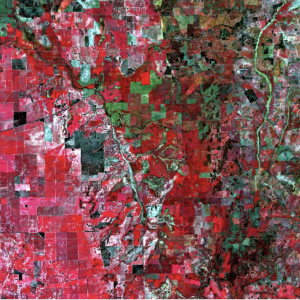
INFORMATION LEVEL 3: Satellite imagery helping farmers
https://ecos.csiro.au/remote-sensing-for-farmers/ The boundary between art and science. Crops (the red area on the left), rivers (in the centre area), bushland (black) and less vegetated areas (green on the right) in 74×54 kms of Western Australia. Credit: European Space Agency. There’s a high-tech tool increasingly available to farmers from Australia to Africa – remote sensing data […]
Read more »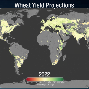
INFORMATION LEVEL 3: Crop projections using climate simulation models
https://svs.gsfc.nasa.gov/4914 https://svs.gsfc.nasa.gov/vis/a000000/a004900/a004914/WheatMapFuture.mp4 Climate change will affect agricultural production worldwide. Average global crop yields for maize, or corn, may see a decrease of 24% by late century, if current climate change trends continue. Wheat, in contrast, may see an uptick in crop yields by about 17%. The change in yields is due to the projected increases […]
Read more »
INFORMATION LEVEL 3: Airglow-australia
INFORMATION LEVEL 3: Airglow-australia: https://svs.gsfc.nasa.gov/31115 On October 7, 2018, an astronaut onboard the ISS shot this photograph at an altitude of about 250 miles (400 kilometers) over Australia. In this view, stars appear more numerous along the image center where the plane of the disk-shaped Milky Way galaxy extends into space. The orange colors enveloping […]
Read more »